If instead you want your map to emphasize the parcel ID, lot dimensions and other details instead of the land owners (like the GeoPrime map did), there are two ways you can accomplish this:
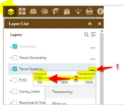
1) On the Overlay Layers list, click the three dots (...) to the right of the Parcels layer, choose Transparency on the popup, then drag the slider to Opaque (0% transparency). Turn off (uncheck) the Parcel Ownership layer. Here is a screen shot to illustrate this:
2) Another option is to turn off the "Parcel Ownership" layer, then go to the "Basemap Gallery" button which is located near the upper right of the map (it's the 4 squares button
