4/22/15

Updated Tax Deed Properties For Sale

The County Treasurer has updated Tax Deed Properties for sale.   You can view the property locations, photos, minimum bid, and other information using this app (click here or click the image below).

For information on how to bid on these properties, click here.

http://browncounty.maps.arcgis.com/apps/MapTour/index.html?appid=ab6e617957704ea68c6aeb07cbf6da1e&webmap=ca89cec2354441d68e9aeeeeb8c68711#
Click to view property photos & other details

4/15/15

Outdoor Warning Sirens in Brown County

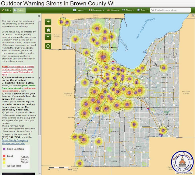
This map shows the locations of the emergency sirens and their approximate sound range:

Outdoor Warning Siren interactive map (click here)

Sound range may be affected by terrain and can change daily depending on weather conditions. Generally, most sirens can be heard within a mile, though some of the newer sirens can be heard from farther away if conditions allow.

Your feedback is wanted on siren tests that are conducted each Wednesday at noon. 

1) On the interactive map, zoom to where you were during the siren test

2) Click the "Editor" button (upper left corner of the map), choose the green circle (can hear siren) or red square (siren not heard), then:

3) Place a green dot on your location if you could hear the siren at that location. 
--OR-- place the red square at the location you did not hear a siren during the Wednesday noon tests.

4) Optional:  If you would like a reply, please leave your phone or email address on the popup that will appear after you place your marker.

Thanks for your help!

If you have questions about this, please contact Brown County Emergency Management at (920) 391-7431 or visit the Brown County Emergency Management web site.

At all times, please use common sense and take shelter when dangerous weather is present in your area whether or not you hear a siren.

Click to open interactive map


4/13/15

More than 30,000 land surveys at your touch

More than 30,000 land surveys are accessible through the Survey Index GIS mapping app.
Find and view surveys by simply zooming in to your area of interest and then clicking on the map.

Some of the latest improvements to the GIS survey index app include:
  • The app works on any computer browser and will scale down to nicely fit mobile device screens (smart phones and tablets).  If used on a smart phone with GPS, the "Find by location" will locate you on the map.
  • The main "Search" box lets you search by addresses and Parcel ID numbers. 
  • Find the Town-Range-Section, Private Claim, and other PLSS information via pop-up by clicking on the map when zoomed out.  When zoomed in, the PLSS information is labeled as map text.
  • The advanced search lets you search by subdivision name, Town-Range-Section, surveyor name, and survey date. 
  • The map Layer List lets you filter surveys by type (CSM, Subdivision, Plat of Survey, Transportation Plat, etc).   Checking "on" survey map layers by type will highlight surveys of the type you choose and the extent of the survey types will be easier to see on the map as they will have a solid fill and include map text labels.  If labels are not wanted, you can turn them off. 
  • More surveyor-specific map layers have been added, such as two-foot contours.
  • Section corners are labeled on the map with the corner name.  Click on the corner symbol to view the tie sheet image and other information about the corner.
  • Better printing capabilities (more page sizes, a better map legend, export options such as PDF, etc).
You can view the new Survey Index app by clicking here. 

Brown County Planning & Land Services staff are continuing efforts to finish indexing the remaining surveys within the City of Green Bay (yellow area on the map).  This incomplete area does contain many surveys, but we know some are still not indexed on this map.   Former County Surveyor Pat Ford has come out of retirement to volunteer his time to help complete the indexing within this area!  A fully complete survey index will be available here as soon as possible.  We anticipate that over 40,000 surveys will be available on this app when finished.

http://browncounty.maps.arcgis.com/apps/webappviewer/index.html?id=c280eb4792dc44d1975b7705d6972440


New blog

The online mapping "Tips & Tricks" posted over the last several months have been imported into this new "blog" format and are posted below.  

The new blog format will make these tips easier for you to search and make the information easier for you to read.

Also, this blog will incorporate other news items coming out of the Brown County Land Information Office.

Three tips on how to make a better custom web map

Brown County online GIS
Three tips on how to make a better map


The GeoPrime web map has many layers.  There are “base map” layers accessible via two buttons on the upper right, and there are many “overlay” layers accessible with the Layers button on the upper left.  Certain key layers are turned “on” by default when you first go into the map, but you may want to adjust settings to make a better map that communicates your intended message.  

Below are a few of ways you can manipulate these map layers to make a better map.  It is always important to keep your map’s purpose in mind as you design it, so that it’s main purpose is easily understood by your map’s audience.  


  1. Remove clutter:   Click the “Layers” button > expand the ‘Addresses,Parcels,Surveys & PLSS’  layer group by clicking the white triangle to the left of the group layer >   uncheck the “Parcels” layer to remove extraneous parcel map text and lines.   You may also want to turn on/off other overlay layers to help reduce clutter.   Also, see step two:

  1. Change the base map:  Go to the Base Map buttons on the upper right, click the triangle drop-down, and choose “No Base Map” from the list of base maps.   Then, turn on only the overlay layers that you need (such as street names) using the Layers button.   The “Standard Base Map” (the base map that’s on by default when you first go into the GeoPrime site) is references a lot of information to help you get your bearings, but may be more information than you need for your final map.

  1. Adjust Layer Transparency:  There are “slider” bars next to every layer which will let you bring a layer more to the forefront or set it more to the background.  Adjust the transparency to make your primary map features stand out.   You can adjust transparency on the base map layers using the slider that appears when you move your mouse cursor over the base map buttons.    It is often helpful to adjust the aerial photo transparency so that your overlay layers stand out more and aren’t overwhelmed by the photo.  


More information:

Click to filter articles by label: