8/10/23

How to measure elevations and heights of trees or structures using BrownDog

A fairly common question is, "What is the elevation of this location?" or "How tall is this ____?" ( building, structure, tree, etc). 

The BrownDog GIS map has a couple of ways to help answer you answer these sorts of questions. All are based on a LiDAR flight completed in April 2020 and all measurements should be considered approximate.

How to determine ground elevations

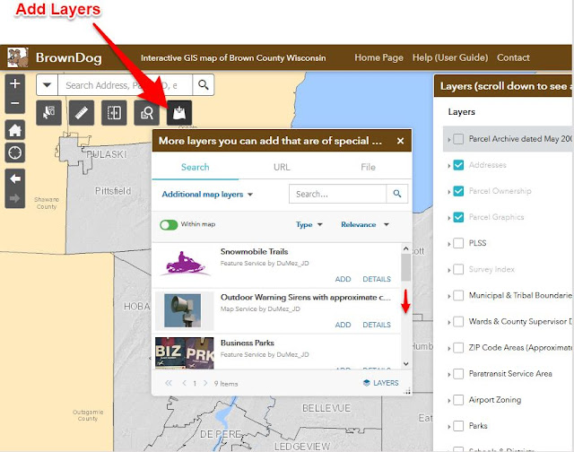
  1. One easy way to obtain ground elevations is to zoom to your area of interest and then scroll down on the list of layers on the right and turn on the layer "Elevation Contours Spring 2020".  The contours are visible only when zoomed in. Contour text (elevations) show as do many spot elevation points. If a contour isn't labeled, you can click on it to view the elevation in a popup.
  2. Another way to get the ground elevation for a particular spot is to turn on the Digital Elevation Model-LiDAR 2020 layer in the Aerials & Historic Maps list of layers on the lower right. Then, with this layer turned on, simply click on the map to view a popup showing the ground elevation. As noted in the popup, elevations are in feet and relative to Mean Sea level (MSL) and the NAVD88 datum.

How to determine heights of buildings, structures, trees, etc 

  1. Look in the list of layers in the Aerials & Historical Maps section on the lower right part of the BrownDog map and turn on BOTH the Digital Elevation Model and the Surface Model layers. (you don't need the hillshade or shaded relief layers).
  2. Zoom to your location of interest, zoom in as far as possible so that you get the most accurate result in the next step
  3.  Then click what you want to measure.  To get the maximum height of a building or tree, make sure you are zoomed in quite far and pick on the darkest red color which represents the tallest or highest areas or things within your map view.  You should be able to make out the feature you want to measure using the color shading but you can also turn on the aerial photo layer if you need an additional visual reference (just keep in mind that above-ground features like structures and trees may appear on the photos to have a bit of "lean" to the side because of the camera angle and perspective).
  4.  The top of the popup has small triangles near the right top of the popup. Click the small triangles to toggle between the Surface or Object elevation and the Ground elevation layer results for the location you clicked. Other map layer information may show up in the popup as well.
  5. To get the height of an object, take note of or copy the ground elevation from the Digital Elevation Model layer and subtract that number from the DSM elevation.  The result of this math will be the height of the object in feet. Round to the nearest foot.  If the number is zero or close to zero, there is likely no object (building, tree, etc) above ground.  It's recommended you make several measurements (several samples) and then use the average elevation for your heightRemember, this information is based on conditions as they were in April 2020 when the LiDAR flight was done, and although this product is pretty accurate, this measurement should be rounded to the nearest whole number and should be considered approximate.

Example:  Get the height of the Interstate 43 bridge over the Fox River

Let's say I want to measure the maximum height of the Leo Frigo bridge (I-43 bridge, also known as the Tower Drive bridge) over the Fox River. I want both the height of the supporting arches  as well as the height of the road deck above the water.  Here is how I will obtain these heights using BrownDog:

  1. First, I zoom in to the bridge. Zooming in gives me the most detail and lets me click more precisely on what I want to measure.
  2.  On the list of layers on the right side of the BrownDog map, I turn on both the Digital Elevation Model (DEM) and the Surface Model (DSM) layers so that the popup in the next step shows the elevations I need from both layers.  When turning on the DSM, I can see the maximum heights of objects have darker red color shading, whereas areas with lower elevations will be yellow and green in color.
  3. Then I click on the darkest red part of the bridge, this appears to be the tallest part of the bridge (the top of the supporting arches).   In the popup, I use the small triangles on the upper right of the popup to click through each record to and take note of the elevation from the DSM (digital surface model).   I'll click on several of the highest points (darkest red) spots that I can see and take multiple samples to make sure I'm getting the highest (tallest) part of the structure. I'm finding the highest part of the bridge arch is about 780 feet.  This is the elevation above mean sea level as noted in the popup.  Next I'll click the small triangle on the popup to get to the ground elevation (or in this example, water elevation).  I see the water elevation was 581.7 feet (as of April 2020).
  4. Then I subtract the ground (water) elevation from the DSM elevation to get the height in feet, so 780 - 581.7 = 198.3 feet.  So, I'm finding the approximate height of the bridge arch over the water was around 198 feet in April 2020.  Because I know the Fox River water level was a couple higher than normal at that time, I'll just round this out to say the top of the arch is about 200 feet above the surface of the water today.
  5. I also want to know the height of the road (bridge deck) so I will also click on a few places that are between the arch structure to get the road deck height.  Most measurements I take show the road elevation at the top of the bridge to be just over 708 feet, so  708 - 581 = 127 feet.  Now I know that when I'm driving over the Tower Drive (I-43) bridge, I'm about 127 feet above the water. I took a screen shot of this on the image below.

You can measure buildings or other types of structures and even the tops of larger trees using the procedures above, but again, keep in mind all your resulting measurements should be considered approximate and are based on data collected in April 2020. 


10/20/22

Letting the BrownDog Out: A better way to use BrownDog on a smart phone or tablet

Although the main BrownDog GIS map does work on smart phones and tablets, there is a free app that you can install to improve the experience.

The free app is called ArcGIS Explorer. You can find this app in the Apple Store or Google Play App Store. When searching, you may see other ArcGIS Apps but the one called Explorer is the one that does not require a login (you can create a login, but it's not necessary; Read on below):

After you have ArcGIS Explorer installed on your phone or tablet, open it, then:

  • On the opening screen you can choose "Continue without Signing In" (small text underneath the login buttons)
  • Once you're in, enter the word "BrownDog" into the map search. 
    • Pick the BrownDog Official GIS map listed there, or choose the Survey Index or other app if you wish
  • If the app asks to "Allow Explorer to use your location?" choose "Allow while using the app". If you don't allow this, the GPS won't work.

Benefits of using the BrownDog (or Survey Index, etc) on the Explorer App:

  • Moving around the BrownDog map with the Explorer app is much smoother and the Explorer app makes viewing the map on a smaller screen much easier.
  • The GPS function works a lot better in Explorer (there is a button near the upper right that will locate you in the map).  Just keep in mind, the GPS on your phone isn't accurate enough to let you precisely locate a property boundary
  • The popup windows are easier to read in the Explorer app. When you tap on the map, the initial popup fills only the bottom part of your phone's screen but you can swipe up on the popup to make it full screen. The popup on a tablet may be to the side of the map if it is a larger screen.
  • Click the 'sandwich' button at the top of the screen to open the list of layers, and to toggle layers on/off. There are many layers, the hungry dog likes a big sandwich.


 Bad dog, but better mobile mapping app.

11/14/19

What's coming in 2020

In 2020, the Brown County Land Information Office will be publishing several new GIS datasets including:

  • Aerial photos from the 1990 flight.  These have been removed from from the PALS department shelf, dusted off, and are now in the process of being scanned and orthorectified.  The 1990 photos are high-quality color images. They look very nice!   Scanning and turning them into a GIS map layer will breathe new life into these old photos. They are still useful for land use change analysis, especially when viewed as a map layer with the other aerial photos we have available on the BrownDog interactive GIS map.
  • New aerial photos.  The photography will take place in the spring of 2020 after snow/ice melt, but before leaves are back on the trees.  Digital processing will occur over the summer, and we hope to have the new images published by October or November 2020.
  • New topographic mapping.  Topographic data will be collected using LiDAR in Spring 2020.  The goal is to produce a "QL1" dataset with 1-foot contours.  This project is being funded by many organizations including the federal government (USGS and FEMA), state grants, several county departments, and many municipalities (thanks to all for helping to pay for this!).   The new topographic / contour data should be available for use by the end of 2020.
Below:  Lambeau Field in Spring 1990.


4/30/19

Changes to Land Records & GIS systems

On the first week of May 2019, Brown County is transitioning from our AS/400 land records and tax system to a new system (LandNav by GCS Software).

This will affect public web sites in the following ways:
  •  The old public Land Records Search page will be retired and replaced by a new GCS public web portal.  The new GCS web portal has a modern look and new capabilities.  It will be similar to the web portals used in many other counties.  The old Land Records search page should automatically redirect to the new one, although you may want to update your web bookmarks when the public URL becomes available. 
  • The BrownDog GIS mapping site will not change much.  The biggest change to BrownDog will be that the parcel popup window will link to the GCS web portal for assessment, tax and other information. 
As we make these computer system upgrades, we plan to keep all sites running although we may get a little behind in data entry during the transition.

We plan have the new system completely in place by May 7, 2019.


2/20/19

New 3-year plan

If you're interested, a new 3-year plan is posted here  (Click here to download the Brown County Land Information Plan 2019-2021.PDF).  This plan format follows the state program guidelines; Much of the document is more of a report than a plan.  If you work with GIS, surveying information, or other Brown County land information, you may find this interesting or useful. 

http://www.gis.co.brown.wi.us/web_documents/LIO/PDF/Brown_County_Land_Info_Plan_2019-2021.pdf


1/18/19

GeoPrime is no more

After being on life support for the last couple of years, we finally pulled the plug on the old GeoPrime mapping site.  Anyone who tries using the URL to GeoPrime will be redirected to the BrownDog map instead.

We launched GeoPrime in 2009 and at the time it was a huge improvement in web mapping. The Adobe Flash technology really made for smooth navigation and nice-looking graphics. 

However, as this article describes, it was time to move on.   GeoPrime was our flagship mapping app for 10 years, and that is a long life for computer software.

BrownDog has nearly all of the capabilities that GeoPrime had.  We will continue to develop the BrownDog mapping app as time permits. 


1/9/19

How to add layers to the BrownDog map

When you first open the BrownDog online GIS map, you see a lot of map layers along the right side of the screen.  These are the layers that many people have asked to be included in this map, and they can be viewed by simply checking them "on".

Brown County produces many other map layers for various projects that are not part of the "main" layer list, yet are requested fairly often by folks like you.

Use the "Add Layers" button illustrated below to look for other map layers that might be useful to you.  As of January 2019, these include:
  • Snowmobile trails (it's January!)
  • Business parks
  • Extraterritorial zoning
  • New subdivisions
  • Parcel archives from 2005, 2010, 2014 and 2017. Clicking these archived parcels will show property tax assessment information from the year selected.
  • Outdoor warning sirens with approximate coverage areas
  • More to come! We will be adding to this list in the coming months.
  • You can also choose the Search dropdown to "ArcGIS Online" to look for GIS map layers produced by other organizations.
Further, if you know a thing or two about spatial data, you can add your own data files such as lat/lon coordinates in a CSV file, shapefile, or GPS file export. To do this, choose the "File" tab at the top of the Add Layers screen. Currently the supported formats include shapefile, CSV, KML, and GPX. Just keep in mind your file may not 'overlay' properly unless you have assigned a coordinate system to your data file.

https://browncounty.maps.arcgis.com/apps/webappviewer/index.html?id=61fba3fd419045e48aa6ba759838387c

Here's an example of how you can use this information.  Say you're interested in property value change through time around Lambeau Field.  You can add the 2005 parcel archive, then start clicking the map.  One parcel across from 1265 Lombardi Ave had a total assessed value of $92,900 in 2005.  As of 2018, it is the location of one of the more noticeable "tailgate houses" and is assessed at over $350,000. Point at the map, click, and BrownDog will fetch the information.  You can turn on the older photos (scroll down on the main layer list) to visually see the land use change. You will notice most of the parcel archive dates coincide with the air photo dates.


10/12/18

Parcel details hard to read? Here's what to do:

When you search for a parcel in BrownDog, the resulting parcel gets highlighted in orange.  Some people like this highlight, others don't.

If you don't want the orange highlight, just click the small X in the search box to clear out your search. This will also remove the orange highlight.

Also, if you want the parcel details (lot dimensions and so forth) to stand out better, you can also adjust the transparency of the "Parcel Graphics" layer by clicking the three dots ( ... ) to the right of the Parcel Graphics layer in the Layer List, then move the slider over to the left to make this layer opaque (0% transparent). 

Click the X in the search bar to remove the orange highlight:


Adjust the transparency of the Parcel Graphics layer to make the details darker and stand out more.  You might also want to turn off the Parcel Ownership layer: 


Scroll down for more articles / tips on how to use the BrownDog online mapping app.

10/10/18

How to View Aerial Photos in the BrownDog map

Here's how to view aerial photography in the BrownDog map:

1) Scroll down on the Layer List on the right, then check on the air photo layers.  It is a long list of layers*.  You can either hover over this list and use your mouse wheel to scroll down, or else click and drag the scrolling bar to the right of the layer list and move it down until you see the air photo layers.  The air photos typically underlay parcels and other layers, so they are near the bottom of the list. 

          --OR--

2)  You can also click the "Basemap Gallery" button near the upper right part of the app. It looks like this:  .  Clicking this button in the BrownDog app will provide you with choices for the underlying base map, which includes aerial photos from various years dating back to 1938.


*  I am hoping our software provider gives us the ability to "group" layers like we had in the old GeoPrime app.  This will help organize the layers and make them all move visible.  Once we are able to set up layer grouping, the layer list will be shorter and you'll be able to find the aerials and other layers faster.


9/28/18

How to print from the BrownDog map

Here is how you can print maps (or create your own PDF) using the BrownDog online GIS map:

1. Open the BrownDog online GIS map (click here), zoom to your area of interest, then click the Printer icon (button) near the upper right part of the BrownDog online GIS map

2. On the Print setup screen, enter your map title, choose your Layout page size, and the map file format you want.  It defaults to PDF, but you can also pick JPG or other image formats from the list.

3.  After entering your title, size and format, click the large blue "Print" button. A graphic is produced after a few moments and will appear in a list.  Simply click the map title in the list to open or download your map PDF (or whatever image format you chose in step 2).

If you need to make adjustments to the map extent/scale or other map elements, click the Advanced button and try out the different options. 


Happy mapping!


How to turn off land owner names and make the parcel details (such as lot dimensions) more prominent

When zoomed in, the BrownDog mapping app defaults to show parcels labeled with land owner names.  A lot of people prefer this 'plat book' style map.  Other parcel details such as parcel ID number and lot dimensions are semi-transparent in an attempt to reduce 'clutter' on a map that is packed full of information.

If instead you want your map to emphasize the parcel ID, lot dimensions and other details instead of the land owners (like the GeoPrime map did),  there are two ways you can accomplish this:


1) On the Overlay Layers list, click the three dots (...) to the right of the Parcels layer, choose Transparency on the popup, then drag the slider to Opaque (0% transparency).   Turn off (uncheck) the Parcel Ownership layer.   Here is a screen shot to illustrate this:


2) Another option is to turn off the "Parcel Ownership" layer, then go to the "Basemap Gallery" button which is located near the upper right of the map (it's the 4 squares button) and then switch the background map to "Parcels".

6/28/18

Access archived parcel data from 2005, 2010, and 2014

You can view Brown County parcel records as "snapshots in time" .  This includes parcel data from 2005, 2010, and 2014.  These dates were chosen the parcel information coincides with the aerial photos of approximately the same date.

You can access this archival information from the BrownDog popup window (when you click on a parcel) or by clicking the links below:
 When you open these apps, you will see the parcel boundaries with land owner names as they existed at the published date.  You can click on parcels to pop up additional archived information including the assessed values of approximately the published date.


12/15/17

GeoPrime... BrownDog... Why more than one GIS mapping app? Which one should I use? Does one have more current data than the other?

Common questions I get lately, along with short answer plus a bit more explanation for those who really want to know more detail:
  • Why does Brown County offer more than one GIS mapping app? 
  • Are the map layers the same?  Is the data current on each?
  • GeoPrime ... BrownDog... Which one should I use? 
The short answer is:  Technology continues to evolve and we are doing the best we can to keep up without causing interruption to service.

Both GeoPrime and BrownDog use the same data source, so parcels and other information are up-to-date on each and in sync. 

However, we will have to retire GeoPrime (probably in 2018) because it is based on technology that is going away. Also in 2018, the Property Search page will be replaced with a new web portal for searching land records.  The new property search site will not link to GeoPrime for the GIS mapping.

If you want a more in-depth answer on the evolution of our online mapping sites, here is a brief history that might help explain:
  • In about 2001 or 2002, Brown County launched it's first online GIS mapping site. I don't think it had a name other than the generic "GIS mapping site"; All I can tell you is that was very clunky. But, it was better than nothing.
  • In 2008-09, "Adobe Flash" was all the rage when it came to internet graphics & web sites.  Around this time, we launched GeoPrime based on Flash technology to replace the old' site. The Flash software made our maps nice looking and made for smoother interaction. GeoPrime has been our flagship online mapping site for almost 10 years now.
  • Also around this time (2008-09), Apple released the iPhone and soon after iPads etc. The smart phones & tablets quickly became ubiquitous.  However, the Flash technology does not work well (or at all) on these devices.  A lot of our users began to complain that GeoPrime does not work for them. There have been security problems and other issues with Flash that have prevented many users from using GeoPrime at all.  Adobe has announced they will be killing Flash and discontinuing support for it.  Following suit, the company we purchased GeoPrime from also notified us that they are no longer supporting GeoPrime.  GeoPrime is not the future.
  • In response, Esri (our primary GIS software vendor) released "ArcGIS Online" several years ago. ArcGIS Online allows us to publish GIS maps and apps in a new way using modern, open internet technology.   It is on this platform we launched BrownDog and other online mapping apps that are designed to work within any browser or on any device including smart phones & tablets.
We have been putting time into building up the BrownDog to meet--and exceed--the capabilities offered in GeoPrime.  The BrownDog isn't quite there yet, but as of Dec 2017 we are getting close.  For example, just this week a new mailing label generator was developed since this capability began failing on GeoPrime.

We rely on our software vendor (Esri) to provide us with the tools and widgets, and they continue to release new and enhanced capabilities. From time to time I receive comments about the design, or questions like "can you change it to ....".  For this I rely mostly on the programmers and software design provided by Esri.

P.S.  Why is the site called "BrownDog"?
  • Long ago, our internal GIS had a custom button that helped our users do common GIS tasks more quickly.  To make this button stand out among the other ones, I gave it a unique icon that was in the form of a little brown dog.   Folks here in the office started to refer to it as "the dog".
  • When it was clear that GeoPrime needed replacement, we wanted to give it a name that was catchy and referenced Brown County somehow.  However, there isn't much we could do with "Brown".   "Brown Map" ...nope.  After kicking around other bad ideas and boring acronyms, we just decided to put our friendly puppy online.  We love our dogs, and of course I think my brown-ish dog, Sunny, is the best dog ever :)
P.S.S.
One of the goals of this blog is to create a "user guide" to the BrownDog. Click the label "BrownDog" on this blog for articles about it. You might also be interested in some of the other news & information provided here.


Click to filter articles by label: