10/12/18

Parcel details hard to read? Here's what to do:

When you search for a parcel in BrownDog, the resulting parcel gets highlighted in orange.  Some people like this highlight, others don't.

If you don't want the orange highlight, just click the small X in the search box to clear out your search. This will also remove the orange highlight.

Also, if you want the parcel details (lot dimensions and so forth) to stand out better, you can also adjust the transparency of the "Parcel Graphics" layer by clicking the three dots ( ... ) to the right of the Parcel Graphics layer in the Layer List, then move the slider over to the left to make this layer opaque (0% transparent). 

Click the X in the search bar to remove the orange highlight:


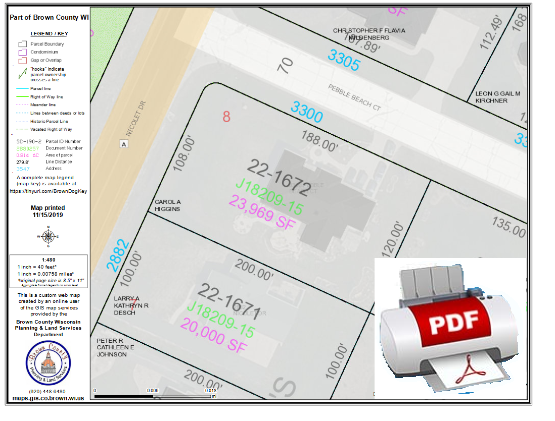
Adjust the transparency of the Parcel Graphics layer to make the details darker and stand out more.  You might also want to turn off the Parcel Ownership layer: 


Scroll down for more articles / tips on how to use the BrownDog online mapping app.

10/10/18

How to View Aerial Photos in the BrownDog map

Here's how to view aerial photography in the BrownDog map:

1) Scroll down on the Layer List on the right, then check on the air photo layers.  It is a long list of layers*.  You can either hover over this list and use your mouse wheel to scroll down, or else click and drag the scrolling bar to the right of the layer list and move it down until you see the air photo layers.  The air photos typically underlay parcels and other layers, so they are near the bottom of the list. 

          --OR--

2)  You can also click the "Basemap Gallery" button near the upper right part of the app. It looks like this:  .  Clicking this button in the BrownDog app will provide you with choices for the underlying base map, which includes aerial photos from various years dating back to 1938.


*  I am hoping our software provider gives us the ability to "group" layers like we had in the old GeoPrime app.  This will help organize the layers and make them all move visible.  Once we are able to set up layer grouping, the layer list will be shorter and you'll be able to find the aerials and other layers faster.


9/28/18

How to print from the BrownDog map

Here is how you can print maps (or create your own PDF) using the BrownDog online GIS map:

1. Open the BrownDog online GIS map (click here), zoom to your area of interest, then click the Printer icon (button) near the upper right part of the BrownDog online GIS map

2. On the Print setup screen, enter your map title, choose your Layout page size, and the map file format you want.  It defaults to PDF, but you can also pick JPG or other image formats from the list.

3.  After entering your title, size and format, click the large blue "Print" button. A graphic is produced after a few moments and will appear in a list.  Simply click the map title in the list to open or download your map PDF (or whatever image format you chose in step 2).

If you need to make adjustments to the map extent/scale or other map elements, click the Advanced button and try out the different options. 


Happy mapping!


How to turn off land owner names and make the parcel details (such as lot dimensions) more prominent

When zoomed in, the BrownDog mapping app defaults to show parcels labeled with land owner names.  A lot of people prefer this 'plat book' style map.  Other parcel details such as parcel ID number and lot dimensions are semi-transparent in an attempt to reduce 'clutter' on a map that is packed full of information.

If instead you want your map to emphasize the parcel ID, lot dimensions and other details instead of the land owners (like the GeoPrime map did),  there are two ways you can accomplish this:


1) On the Overlay Layers list, click the three dots (...) to the right of the Parcels layer, choose Transparency on the popup, then drag the slider to Opaque (0% transparency).   Turn off (uncheck) the Parcel Ownership layer.   Here is a screen shot to illustrate this:


2) Another option is to turn off the "Parcel Ownership" layer, then go to the "Basemap Gallery" button which is located near the upper right of the map (it's the 4 squares button) and then switch the background map to "Parcels".

6/28/18

Access archived parcel data from 2005, 2010, and 2014

You can view Brown County parcel records as "snapshots in time" .  This includes parcel data from 2005, 2010, and 2014.  These dates were chosen the parcel information coincides with the aerial photos of approximately the same date.

You can access this archival information from the BrownDog popup window (when you click on a parcel) or by clicking the links below:
 When you open these apps, you will see the parcel boundaries with land owner names as they existed at the published date.  You can click on parcels to pop up additional archived information including the assessed values of approximately the published date.


Click to filter articles by label: