11/14/19

What's coming in 2020

In 2020, the Brown County Land Information Office will be publishing several new GIS datasets including:

  • Aerial photos from the 1990 flight.  These have been removed from from the PALS department shelf, dusted off, and are now in the process of being scanned and orthorectified.  The 1990 photos are high-quality color images. They look very nice!   Scanning and turning them into a GIS map layer will breathe new life into these old photos. They are still useful for land use change analysis, especially when viewed as a map layer with the other aerial photos we have available on the BrownDog interactive GIS map.
  • New aerial photos.  The photography will take place in the spring of 2020 after snow/ice melt, but before leaves are back on the trees.  Digital processing will occur over the summer, and we hope to have the new images published by October or November 2020.
  • New topographic mapping.  Topographic data will be collected using LiDAR in Spring 2020.  The goal is to produce a "QL1" dataset with 1-foot contours.  This project is being funded by many organizations including the federal government (USGS and FEMA), state grants, several county departments, and many municipalities (thanks to all for helping to pay for this!).   The new topographic / contour data should be available for use by the end of 2020.
Below:  Lambeau Field in Spring 1990.


4/30/19

Changes to Land Records & GIS systems

On the first week of May 2019, Brown County is transitioning from our AS/400 land records and tax system to a new system (LandNav by GCS Software).

This will affect public web sites in the following ways:
  •  The old public Land Records Search page will be retired and replaced by a new GCS public web portal.  The new GCS web portal has a modern look and new capabilities.  It will be similar to the web portals used in many other counties.  The old Land Records search page should automatically redirect to the new one, although you may want to update your web bookmarks when the public URL becomes available. 
  • The BrownDog GIS mapping site will not change much.  The biggest change to BrownDog will be that the parcel popup window will link to the GCS web portal for assessment, tax and other information. 
As we make these computer system upgrades, we plan to keep all sites running although we may get a little behind in data entry during the transition.

We plan have the new system completely in place by May 7, 2019.


2/20/19

New 3-year plan

If you're interested, a new 3-year plan is posted here  (Click here to download the Brown County Land Information Plan 2019-2021.PDF).  This plan format follows the state program guidelines; Much of the document is more of a report than a plan.  If you work with GIS, surveying information, or other Brown County land information, you may find this interesting or useful. 

http://www.gis.co.brown.wi.us/web_documents/LIO/PDF/Brown_County_Land_Info_Plan_2019-2021.pdf


1/18/19

GeoPrime is no more

After being on life support for the last couple of years, we finally pulled the plug on the old GeoPrime mapping site.  Anyone who tries using the URL to GeoPrime will be redirected to the BrownDog map instead.

We launched GeoPrime in 2009 and at the time it was a huge improvement in web mapping. The Adobe Flash technology really made for smooth navigation and nice-looking graphics. 

However, as this article describes, it was time to move on.   GeoPrime was our flagship mapping app for 10 years, and that is a long life for computer software.

BrownDog has nearly all of the capabilities that GeoPrime had.  We will continue to develop the BrownDog mapping app as time permits. 


1/9/19

How to add layers to the BrownDog map

When you first open the BrownDog online GIS map, you see a lot of map layers along the right side of the screen.  These are the layers that many people have asked to be included in this map, and they can be viewed by simply checking them "on".

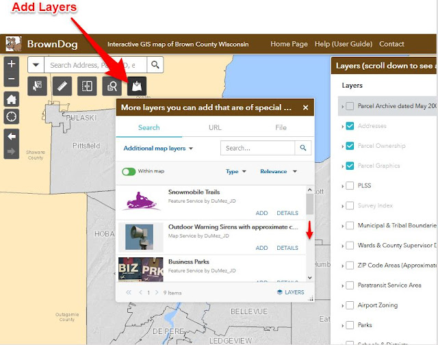
Brown County produces many other map layers for various projects that are not part of the "main" layer list, yet are requested fairly often by folks like you.

Use the "Add Layers" button illustrated below to look for other map layers that might be useful to you.  As of January 2019, these include:
  • Snowmobile trails (it's January!)
  • Business parks
  • Extraterritorial zoning
  • New subdivisions
  • Parcel archives from 2005, 2010, 2014 and 2017. Clicking these archived parcels will show property tax assessment information from the year selected.
  • Outdoor warning sirens with approximate coverage areas
  • More to come! We will be adding to this list in the coming months.
  • You can also choose the Search dropdown to "ArcGIS Online" to look for GIS map layers produced by other organizations.
Further, if you know a thing or two about spatial data, you can add your own data files such as lat/lon coordinates in a CSV file, shapefile, or GPS file export. To do this, choose the "File" tab at the top of the Add Layers screen. Currently the supported formats include shapefile, CSV, KML, and GPX. Just keep in mind your file may not 'overlay' properly unless you have assigned a coordinate system to your data file.

https://browncounty.maps.arcgis.com/apps/webappviewer/index.html?id=61fba3fd419045e48aa6ba759838387c

Here's an example of how you can use this information.  Say you're interested in property value change through time around Lambeau Field.  You can add the 2005 parcel archive, then start clicking the map.  One parcel across from 1265 Lombardi Ave had a total assessed value of $92,900 in 2005.  As of 2018, it is the location of one of the more noticeable "tailgate houses" and is assessed at over $350,000. Point at the map, click, and BrownDog will fetch the information.  You can turn on the older photos (scroll down on the main layer list) to visually see the land use change. You will notice most of the parcel archive dates coincide with the air photo dates.


Click to filter articles by label: